There is no better way to see Europe than from the window of a train. From London you can be in Paris, Brussels or Amsterdam in a few hours without ever leaving the ground, and from there the continent opens up: cog railways grinding to Alpine summits, the Bergen line crossing the roof of Norway to meet the Flåm railway plunging to a fjord, the Rhine sliding past its castles, and the little coastal line linking the villages of the Cinque Terre. This is a guide to the great gateways and scenic lines, grouped by region — the raw material for an interrail trip, or a single unforgettable journey.
Rail is often the most accessible way to travel in Europe, but it varies hugely by country and by station — some have level boarding and staffed assistance, others have steps and gaps. Assistance usually needs booking ahead (often 24–48 hours), so plan it in. Where we haven't confirmed a specific detail we say "not yet checked", and we'd always ask you to arrange assistance with the operator before you travel.
Eurostar gateways
Where a European rail trip begins — the great stations a few hours from London, and the cities around them.
London St Pancras International

The Eurostar terminus in London and the front door to European rail.
This is where it all begins. St Pancras is a genuinely handsome Victorian station, all red brick and that great arched roof, and it is the only place in Britain you board a train straight to the continent. The Eurostar security and passport control sit upstairs, so give yourself proper time before departure rather than turning up like it is a normal domestic train. Once you are through, the champagne bar under the roof is a nice send-off if you fancy it. From here you can reach Paris, Brussels, Lille and Amsterdam directly, which makes it the natural first move for any Interrail or Eurail trip built around Europe rather than the UK.
Our tip Check in well ahead of departure. Eurostar closes boarding earlier than you would expect, and the passport queue can be long in summer.
Visiting — good to know
Accessible toilets
Step-free / wheelchair access not yet checked — please confirm with the venue.
Access last checked 13 Jul 2026 — always confirm with the venue.
Worth watching
More Wikipedia
Also featured in Accessible London
Paris (Gare du Nord)

Europe's busiest station and the Eurostar arrival point in Paris.
Gare du Nord is where most people first step off onto the continent, and it is a lot. It is the busiest railway station in Europe by passenger numbers, so expect noise, crowds and a bit of chaos the moment you arrive. Do not judge Paris by it. The Metro and RER connect straight from the station, so you can be at your hotel or across town quickly. As a rail hub it is superb: Eurostar trains to London and Belgium, plus onward high-speed services fan out from here and nearby Gare de Lyon for the south. The catch is pickpockets work the busy concourse, so keep your bag zipped and your phone away.
Our tip For trains south to Lyon, the Alps or Spain you usually need a different Paris station, often Gare de Lyon. Factor in a cross-city Metro hop between them.
Visiting — good to know
Step-free / wheelchair access
For blind & low-vision visitors A large, busy terminus with accessible routes, lifts and staff assistance, but crowded and complex; tactile paving and platform-edge care needed.
Sensory A very busy, echoing, crowded major station - high-stimulation, with announcements and bustle; arrive with time to spare.
Access last checked 5 Jul 2026 — always confirm with the venue.
Worth watching
- ♿️ EUROSTAR AS A WHEELCHAIR USER | London to Paris🇫🇷 Full review Wheelsnoheels - Gem Hubbard
- Eurostar Blew Me Away! Watch This Incredible Wheelchair Ramp in Action No Limb Jim
- Essential Tips for Navigating Gare du Nord in Paris Miles Away with Us
More Wikipedia
Lille

A handsome Flemish city and a fast rail interchange in northern France.
Lille is the gateway most people blow straight through, and that is their loss. Eurostar stops here on the way to Paris and Brussels, and the city itself is a proper surprise: a grand old Flemish centre with a big square, good beer, and food that leans as much Belgian as French. It makes an easy first or last night on a trip, cheaper and calmer than Paris. As an interchange it is excellent, with high-speed trains south into France and quick hops to Brussels. The two main stations, Lille-Europe and Lille-Flandres, sit a short walk apart, so know which one your onward train leaves from.
Our tip The two stations are close but not the same building. Check whether your connection is at Lille-Europe or Lille-Flandres before you arrive.
Visiting — good to know
Step-free / wheelchair access
For blind & low-vision visitors A modern, accessible interchange station with lifts and level access; Lille's old town beyond has cobbled, walkable streets and grand squares.
Sensory A busy modern station; Lille's Grand Place and old town are lively but calmer, with cafe bustle.
Access last checked 5 Jul 2026 — always confirm with the venue.
Worth watching
- Gare de Lille Europe, Lille, France - 9th January, 2013 Moss Travel Media
- French Train Stations - Lille Europe and Lille Flandres IAmDistracted
More Wikipedia
Brussels (Bruxelles-Midi)

Belgium's international rail hub and Eurostar stop between London and Amsterdam.
Brussels-Midi is the great crossroads of the northern network. Eurostar to London, ICE to Germany, and trains on to Amsterdam all pass through, which makes it one of the most useful interchanges on the continent. The station itself is functional rather than lovely, and the area around it has a rough edge, so keep your wits about you and do not linger with luggage. The city proper is a short ride away and well worth a stop for the Grand-Place, the chocolate and the beer. Above all, Brussels is your pivot: from here you can strike east into Germany, north to the Netherlands, or south back into France.
Our tip The station district is scruffy and known for bag theft. Move through it, do not sit around, and keep valuables close.
Visiting — good to know
Step-free / wheelchair access Accessible toilets
For blind & low-vision visitors A large, busy interchange (Bruxelles-Midi) with accessible routes and lifts but crowds and some complexity; staff assistance available, platform-edge care needed.
Sensory A busy, functional, sometimes chaotic major station - high-stimulation; the city's grand squares beyond are calmer.
Access last checked 5 Jul 2026 — always confirm with the venue.
Worth watching
More Wikipedia
Amsterdam (Centraal)

A grand waterfront station and the Dutch rail hub at the top of the Eurostar route.
Amsterdam Centraal is one of the loveliest big stations you will use, a great brick pile sitting right on the water at the edge of the old centre. Eurostar now runs direct from London to here, and a smart new terminal has gone in for the trip back, which needs its own passport control so allow time. Step out of the front and you are among the canals within minutes, with trams and the metro right outside. As a hub it links you to Germany by ICE and across the Netherlands and Belgium besides. It is the natural northern anchor of a rail trip, and a fine place to start or finish.
Our tip The return Eurostar to London needs UK-bound passport checks at the station, so build in extra time and do not cut the check-in fine.
Visiting — good to know
Step-free / wheelchair access Accessible toilets
For blind & low-vision visitors A grand, largely accessible station with lifts and level access, opening onto the flat, canal-laced city; watch for cyclists and tram tracks outside.
Sensory A busy, bustling station and canal-city front - lively with trams, bikes and crowds; the canals and museums are calmer.
Access last checked 5 Jul 2026 — always confirm with the venue.
Worth watching
More Wikipedia
Bruges

Belgium's best-preserved medieval town, a short hop from Brussels by train.
Bruges is the day trip that makes a Belgian leg worth it. Direct trains run from Brussels at least a couple of times an hour and take a bit over an hour, so you can be wandering the canals and cobbled lanes by mid-morning. The historic centre is a UNESCO site and about as picture-book as Europe gets, all step-gabled houses, a big market square and a belfry you can climb. From the station it is a pleasant fifteen-minute walk into the middle. The honest catch is that it is no secret: the core gets very busy with day-trippers, so go early or stay a night to have the place to yourself once the coaches leave.
Our tip Stay overnight if you can. Bruges empties beautifully in the evening once the day-trip crowds have gone home.
Visiting — good to know
Step-free / wheelchair access
For blind & low-vision visitors A fairy-tale medieval city of cobbled, largely flat but uneven streets, canals and bridges; the centre is walkable but cobbled, with open canal water.
Sensory A calm, beautiful, popular canal city - gently busy with visitors midday, peaceful early and in the back streets, with bells and water.
Access last checked 5 Jul 2026 — always confirm with the venue.
Worth watching
More Wikipedia
The Alps
The heart of scenic rail — cog railways to the summits, and the panoramic expresses between them.
Lucerne

A lakeside city and rail hub for Mount Pilatus, Rigi and the Lake Lucerne steamers.
Lucerne is where a lot of Swiss rail trips find their feet. The station sits right on the lake in the middle of town, with the old covered Chapel Bridge a couple of minutes away, and it doubles as the launch pad for some of the country's record-breaking mountain railways. From here or nearby jetties you can reach the Pilatus cog railway, the steepest in the world, and the Rigi line, Europe's very first mountain railway. Lake steamers leave from right outside the station, so you can mix boat and train into one loop. It is also a hub in the network proper, with fast trains to Zurich, Bern and Interlaken, which makes it an ideal base.
Our tip The classic circuit combines a lake paddle steamer one way with a cog railway the other. Doing it as a loop beats an out-and-back.
Visiting — good to know
Step-free / wheelchair access Accessible parking Accessible toilets
For blind & low-vision visitors A lakeside city with a largely level, walkable old town, famous covered bridges and a station right by the lake; some cobbles, open lake water.
Sensory A calm, scenic lakeside city of mountains and water - gently busy at the bridges, peaceful along the promenade.
Access last checked 5 Jul 2026 — always confirm with the venue.
Worth watching
- FIRST CLASS on Switzerland’s TRAINS for 15 days DownieLive
- SBB Rollstuhlreise ZSLSchweiz
- How To Ride The Luzern-Interlaken Express | Panoramic Swiss Train Ride | Swiss Grand Train Tour Aplins in the Alps
More Wikipedia
Also featured in Grand Train Tour of Switzerland
Interlaken

The rail gateway to the Bernese Oberland, sitting between two lakes.
Interlaken is the staging post for the whole Jungfrau region, wedged between Lake Thun and Lake Brienz with the big peaks rising behind. It has two stations, and the one you want for the mountains is Interlaken Ost, which is where the cog railways up to Lauterbrunnen, Grindelwald and ultimately the Jungfraujoch begin. The town itself is touristy and not the point; treat it as the place you sleep and reprovision before heading up. It also sits on the scenic GoldenPass route toward Montreux, so it works as a hinge between the Bernese Oberland and Lake Geneva. Base yourself here and the best of alpine Switzerland is a short cog-railway ride away.
Our tip Make sure you are at Interlaken Ost, not West, for the mountain trains. They are a couple of kilometres apart with frequent local connections between.
Visiting — good to know
Step-free / wheelchair access Accessible parking Accessible toilets
For blind & low-vision visitors A resort town between two lakes with a largely level, walkable centre and grand mountain views; a gateway to the high railways, some uneven ground.
Sensory A calm, scenic mountain-resort town - gently busy with tourists in season, with mountain air and lake calm.
Access last checked 5 Jul 2026 — always confirm with the venue.
Worth watching
More Wikipedia
Also featured in Grand Train Tour of Switzerland
Lauterbrunnen Valley

A dramatic glacial valley of cliffs and waterfalls, reached by cog railway from Interlaken.
Lauterbrunnen is the valley that put the drama into the Bernese Oberland. It is a deep glacial trench walled by cliffs, with something like 72 waterfalls, the most famous being the Staubbach which drops nearly 300 metres down the rock face beside the village. A cog railway runs in from Interlaken Ost, and from the valley floor further mountain trains climb to the car-free villages of Wengen and Mürren. That car-free bit matters: you leave the car behind and let the trains do the climbing, which is exactly the point of the place. It is also the lower gateway to the Jungfraujoch, so most trips to the high station pass through here.
Our tip Use the valley as your base and ride up to car-free Wengen for the views. It is only about eleven minutes on the cog train.
Visiting — good to know
Step-free / wheelchair access
For blind & low-vision visitors A dramatic glacial valley of sheer cliffs and 72 waterfalls, with a largely level valley-floor village and path; the walls are vertical, the falls spectacular.
Sensory A calm, awe-inspiring valley of falling water and towering cliffs - peaceful and elemental, gently busy in the village.
Access last checked 5 Jul 2026 — always confirm with the venue.
More Wikipedia
Jungfraubahn to the Jungfraujoch

A cog railway bored through the Eiger to Europe's highest station, the Top of Europe.
This is the big one. The Jungfraubahn climbs from Kleine Scheidegg up to the Jungfraujoch at 3,454 metres, the highest railway station in Europe, and it does it by tunnelling straight through the Eiger and the Monch. Trains have been making the trip since 1912, which is a staggering thought when you are inside the mountain. At the top there is an ice palace, viewing terraces and glacier views that on a clear day are genuinely once-in-a-lifetime. Now the honest bit: it is expensive, it is busy, and the altitude is real, so take it slowly up there and do not be surprised by a headache or breathlessness. Pick a clear-weather day or you will pay a lot to stand in cloud.
Our tip Only go on a forecast clear day. Cloud at the top wipes out the whole point, and the fare does not come cheap.
Plan your visit
- Opening
- Open 365 days a year.
- Admission
- From CHF 119.60.
- Booking
- The fastest route of Interlaken Ost <> Grindelwald Terminal (Eiger Express) <> Eigergletscher <> Jungfraujoch is barrier-free. If you want to travel via Kleine Scheidegg, booking in advance by telephone is essential. Trains depart from Kleine Scheidegg where staff are required to help passengers get on and off at Kleine Scheidegg, Eigergletscher and Jungfraujoch stations. Registration via the Contact Center Handicap.
- Allow
- With the Wengernalp Railway via Grindelwald or Lauterbrunnen: The journey from Grindelwald takes 1 hour 26 minutes there and 1 hour 26 minutes back. We recommend at least 5–6 hours to allow a reasonable amount of time on the Jungfraujoch. From Grindelwald Terminal with the Eiger Express: The journey from Grindelwald Terminal takes 45 minutes there and 45 minutes back. We recommend at least 3.5–4.5 hours to allow a reasonable amount of time on the Jungfraujoch.
Visitor information checked 13 Jul 2026. Opening and prices can change.
Visiting — good to know
Step-free / wheelchair access not yet checked — please confirm with the venue.
For blind & low-vision visitors There is a considerable risk of snow blindness on the glacier if sunglasses are not worn.
Sensory The ambient temperature drops with increasing altitude, and temperatures are often surprisingly cool even in midsummer.
Access last checked 13 Jul 2026 — always confirm with the venue.
Worth watching
More Tickets · Venue access information · Wikipedia
Zermatt

A car-free alpine resort beneath the Matterhorn, reached only by train.
Zermatt sits at the foot of the Matterhorn and, crucially, it is car-free. Private vehicles stop down the valley at Tasch, and you finish the journey on the Matterhorn Gotthard Bahn, a twelve-minute ride into the village itself. That makes arriving part of the pleasure. From Zermatt you can ride the Gornergrat railway, the highest open-air cog railway in Europe, up to a ridge with a full-on view of the Matterhorn and a ring of glaciers. It is also one end of the Glacier Express, so many people start or finish that famous journey here. The catch is it is a premium resort with premium prices, and in peak season it is far from quiet.
Our tip The Gornergrat railway station is right opposite the main station, so you can arrive and head straight up for the Matterhorn view.
Access not yet checked — please confirm with the venue before you travel.
Worth watching
More Wikipedia
Also featured in Grand Train Tour of Switzerland
Glacier Express
A panoramic all-day journey between Zermatt and St Moritz across the Swiss Alps.
The Glacier Express is billed, with a wink, as the slowest express in the world, and that is the whole idea. It runs all day between Zermatt and St Moritz in panoramic carriages with windows curving up to the roof, crossing high passes, spiral tunnels and the country's alpine heart. It is jointly run by the Matterhorn Gotthard Bahn and the Rhaetian Railway, and it shares its most spectacular section with UNESCO-listed track. Here is the catch you must plan around: seat reservation is compulsory and costs extra on top of any rail pass, and popular dates sell out, so book well ahead. Take the food or bring your own, and just let the day unfold past the glass.
Our tip Reservation is obligatory and separate from your rail pass. Book it early, especially for summer and the peak autumn colours.
Plan your visit
- Opening
- The Glacier Express operates daily apart from during the annual break from mid-October to the beginning of December; winter timetable December - April and summer timetable May - October.
- Admission
- The total price consists of a mandatory seat reservation and the price of the ticket.
- Booking
- The tickets and seat reservations can be purchased on the official Glacier Express website; due to high demand, booking in advance is advisable.
- Allow
- The entire trip on the Glacier Express lasts around 8 hours.
Visitor information checked 13 Jul 2026. Opening and prices can change.
Access not yet checked — please confirm with the venue before you travel.
Worth watching
More Tickets · Venue access information · Wikipedia
Bernina Express
A panoramic ride from Switzerland to Italy over the highest Alpine railway pass.
The Bernina Express runs from Chur, the oldest town in Switzerland, down to Tirano in Italy, and it packs an astonishing amount into a few hours. It climbs to Ospizio Bernina at 2,253 metres, the highest railway crossing in the Alps, with no rack or cog to help, just sheer engineering. Much of the route is UNESCO World Heritage, taking in the curving Landwasser Viaduct on the Albula section and the looping circular Brusio viaduct lower down. The reward at the end is arriving among the palm trees of Italy having started amid glaciers. You must reserve a seat, either when you buy the ticket or as a supplement on a regional fare. The panoramic windows are lovely but do not open, so hop off at stops for photos.
Official information: Official website not yet identified.
Our tip Seats must be reserved. The windows are sealed for the panorama, so use the station stops if you want clear photos.
Visiting — good to know
Partial wheelchair access
The journey is experienced seated in a panoramic carriage, with step-assisted boarding rather than level entry throughout. Intermediate alpine stops such as Ospizio Bernina sit above 2,200 m, where platforms can be short and snow-covered for much of the year, so getting off for photos is not always straightforward.
For blind & low-vision visitors A spectacular scenic railway over the Bernina Pass (UNESCO) - a comfortable, seated, step-assisted journey with panoramic windows; the glaciers and viaducts are the draw.
Sensory A calm, breathtaking scenic rail journey through glaciers and palm-lined valleys - relaxing and immersive, gently busy in season.
Access last checked 6 Jul 2026 — always confirm with the venue.
Worth watching
GoldenPass Line

A scenic panoramic route between Interlaken and Montreux via Gstaad.
The GoldenPass connects Interlaken in the Bernese Oberland with Montreux on Lake Geneva, running through Gstaad, Chateau-d'Oex and the green Simmental in between. It is gentler than the high alpine lines, more rolling pasture and pretty villages than glaciers, which makes it a lovely, relaxed way to move between two very different corners of Switzerland. The newest GoldenPass Express trains pull off a genuinely clever trick, changing rail gauge while moving so they can run right through without you having to change. There is also a nostalgic 1930s-style Belle Epoque service on part of the route that is worth catching if the timing works. It is a joining-up journey as much as a destination in itself.
Official information: Official website not yet identified.
Our tip The through GoldenPass Express saves a change at Zweisimmen. Check which service you are booking, as not all run the full route without a swap.
Visiting — good to know
Step-free / wheelchair access Accessible parking
For blind & low-vision visitors A scenic Swiss line (Montreux to Interlaken/Lucerne) of panoramic trains - comfortable, seated, step-assisted; lakes, vineyards and mountains from the window.
Sensory A calm, scenic rail journey through Swiss lakes and mountains - relaxing and immersive, the changing views the pleasure.
Access last checked 5 Jul 2026 — always confirm with the venue.
Worth watching
- GOLDENPASS EXPRESS: Switzerland's Newest Panoramic Train Line – Everything You Need to Know The Traveling Swiss – Louis & Alexis
More Wikipedia
Innsbruck

An alpine city ringed by peaks and the meeting point of Austria's mountain railways.
Innsbruck is the capital of the Tyrol and one of the most dramatically set cities you will pass through, with the Nordkette range rising straight up behind the rooftops. The main station is a busy junction where several routes meet: the Arlberg line west toward Switzerland, the Brenner line south into Italy, and the line north to Germany. That makes it a natural place to break a journey. The old town is a ten-minute walk from the station, all painted facades and arcades, with the famous Golden Roof at its heart. A funicular and cable car will carry you up the Nordkette from the edge of the centre for a big mountain view without leaving the city. Compact, handsome and well connected.
Our tip The Nordkette cable car starts near the centre and climbs high fast. It is an easy half-day if you have a connection to kill.
Visiting — good to know
Step-free / wheelchair access Accessible toilets
For blind & low-vision visitors An alpine city with a largely level, walkable old town beneath dramatic peaks, and a funicular/cable car to the heights; some cobbles, grand mountain backdrop.
Sensory A calm, scenic mountain city - gently busy in the old town, with alpine air and the peaks all around.
Access last checked 5 Jul 2026 — always confirm with the venue.
Worth watching
More Wikipedia
Germany and Central Europe
Mountain-crossing feats of Victorian engineering, and the castle-lined Rhine.
Semmering Railway

The world's first mountain railway, a UNESCO-listed line of tunnels and viaducts in Austria.
The Semmering is a piece of railway history you can simply buy a ticket and ride. Built in the 1840s and 50s between Gloggnitz and Murzzuschlag, it was the first mountain railway in Europe built to standard gauge, driven over ferociously difficult terrain by tens of thousands of workers under the engineer Carl von Ghega. It went on to become the first railway line anywhere to be made a UNESCO World Heritage Site. The line still carries regular trains as part of Austria's Southern Railway, so you do not need a special tourist service; an ordinary train takes you across its curving viaducts and through its tunnels. Sit on the right heading south for the best of the valley views, and spare a thought for how it was built without a single machine we would recognise.
Official information: Official website not yet identified.
Our tip You do not need a tourist train. Regular scheduled services run the line, so it is easy to ride cheaply on a normal ticket or pass.
Visiting — good to know
Step-free / wheelchair access
For blind & low-vision visitors The world's first mountain railway (UNESCO), a scenic line of viaducts and tunnels - a seated, step-assisted journey; the engineering and scenery are the draw.
Sensory A calm, historic scenic rail journey through wooded mountains - relaxing and immersive, quietly grand.
Access last checked 5 Jul 2026 — always confirm with the venue.
Worth watching
More Wikipedia
Arlberg Railway
A scenic 1880s mountain line between Innsbruck and Bludenz over the Arlberg pass.
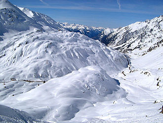
The Arlberg line is Austria's only east-west mountain railway, climbing over 1,300 metres between Innsbruck and Bludenz on its way toward the Swiss border. Built in the 1880s, it is a proper feat of Victorian-era engineering, with daring bridges like the Trisanna and a long summit tunnel under the pass. On the way it threads the Inn valley, climbs past the ski country around St Anton, and drops through forested valleys on the far side. The beauty of it is that it is not a tourist special; fast international trains use it every day, so you cross the Arlberg simply by taking the normal train between Switzerland and Austria. If you are routing between Zurich and Innsbruck, you are on it whether you planned to be or not.
Official information: Official website not yet identified.
Our tip This is the standard route between Zurich and Innsbruck, so you can ride it on an ordinary through service without any special booking.
Visiting — good to know
Step-free / wheelchair access Accessible parking
For blind & low-vision visitors A scenic Austrian mountain line through the Alps - a comfortable, seated, step-assisted journey; dramatic alpine scenery from the window, snowy in winter.
Sensory A calm, scenic alpine rail journey - relaxing and immersive, the mountains and valleys unfolding from the window.
Access last checked 5 Jul 2026 — always confirm with the venue.
Worth watching
More Wikipedia
Rhine Valley Line

The West Rhine railway through the castle-lined UNESCO Rhine gorge in Germany.
The West Rhine line hugs the left bank of the river between Cologne and Mainz, and the golden stretch is the Rhine gorge between Koblenz and Bingen. This 65-kilometre section is a UNESCO World Heritage landscape, and nowhere in Europe do so many castles crowd along a single river; roughly 40 of them stand on the slopes and crags above the water. You pass the Marksburg, the rival Katz and Maus castles, and just south of Sankt Goar the legendary Lorelei rock, where the river narrows and deepens. The best part is you do not need a special train: ordinary regional services run the line, so you can hop on and off at the wine villages as you please. Sit on the river side, which is the left heading south.
Official information: Official website not yet identified.
Our tip Take a slower regional train, not the fast ICE, and sit on the river side. The stopping trains let you jump off at riverside villages.
Visiting — good to know
Partial wheelchair access Accessible parking Accessible toilets
For blind & low-vision visitors A scenic riverside line through the Rhine Gorge, past castles and vineyards - a seated, step-assisted journey; the castles and river are the draw, best from the window.
Sensory A calm, romantic scenic rail journey along the Rhine of castles and vineyards - relaxing and immersive.
Access last checked 5 Jul 2026 — always confirm with the venue.
Worth watching
- Koblenz Accessible Walks with Wheelchairs The Outdoor Guide with Julia Bradbury
Cologne

A major German rail hub with the great Gothic cathedral right beside the platforms.
Cologne has one of the great station arrivals in Europe: you walk out of the main hall and the enormous Gothic cathedral is right there, filling the sky in front of you. The Hauptbahnhof is one of Germany's busiest and its western international hub, with high-speed ICE trains, EuroCity services and Eurostar all calling, plus it sits at the northern end of the scenic Rhine Valley line. That makes it a natural pivot for anyone routing between the Low Countries, France and the German-speaking heartland. The cathedral is free to enter and worth every minute, and you can climb the tower if your legs are willing. As stopovers between trains go, few are this rewarding for so little effort.
Our tip The cathedral is free and thirty seconds from the platforms, ideal for a stopover. The tower climb is steep but the view over the Rhine pays off.
Visiting — good to know
Partial wheelchair access
The old town and Rhine riverfront are flat and mostly paved, though the cathedral square and surrounding lanes use uneven stone setts. The cathedral's main floor is described as largely accessible, but the tower climb is a long, steep flight of steps with no step-free alternative.
For blind & low-vision visitors A cathedral city with a vast Gothic cathedral right by the station (largely accessible, some uneven stone) and a flat, walkable old town by the Rhine.
Sensory A busy cathedral-and-river city - lively around the Dom and old town, with the cathedral a calm, echoing refuge.
Access last checked 6 Jul 2026 — always confirm with the venue.
More Wikipedia
Black Forest Railway

A scenic German line of loops and tunnels through the Black Forest to Lake Constance.
The Black Forest Railway, the Schwarzwaldbahn, cuts through the heart of southern Germany's forest country between Offenburg and Singen, carrying on to Lake Constance and the Swiss border. It was the first mountain railway to use looping curves to gain height, artificially lengthening itself so it could climb without a rack, and it is dotted with tunnels as it winds through the Kinzig valley. Along the way it serves Triberg, home to some of Germany's highest waterfalls and a heartland of the cuckoo-clock trade. Best of all it is run with ordinary regional trains, often double-deckers, so the top deck gives you a grandstand view for the price of a normal ticket. No reservation, no fuss, just a lovely half-day through the woods.
Official information: Official website not yet identified.
Our tip Grab an upstairs seat on the double-decker regional trains for the best view, and break the trip at Triberg for the waterfalls.
Visiting — good to know
Partial wheelchair access
A seated journey on ordinary regional trains with step-assisted boarding rather than guaranteed level entry. The prized upper deck of the double-decker carriages is reached only by internal stairs, and the smaller forest stations along the line vary in platform height and surface.
For blind & low-vision visitors A scenic German mountain line of spirals and tunnels through forest - a seated, step-assisted journey; the deep forest and viaducts from the window.
Sensory A calm, scenic rail journey through the dark, wooded Black Forest - relaxing and immersive, green and peaceful.
Access last checked 6 Jul 2026 — always confirm with the venue.
More Wikipedia
Scandinavia
Two of the greatest railway journeys on earth, meeting in the fjords.
Bergen Line

The highest mainline railway in northern Europe, across the Hardangervidda plateau.
The Bergen Line runs between Oslo and Bergen and is one of the great train rides of Europe, precisely because it is not a tourist special but the ordinary way to cross Norway. It is the highest mainline railway in northern Europe, climbing onto the bare Hardangervidda plateau and passing Finse, the highest station on the route, sitting above the tree line in a landscape of snow, lakes and empty mountain. It is a long day, six to seven and a half hours, and the weather up top can be wild even in summer, which is part of the atmosphere. Most people ride it in tandem with the Flam branch. Book a seat in summer, as it is deservedly popular, and take the window on either side because the views swap constantly.
Official information: Official website not yet identified.
Our tip Break the journey at Myrdal to ride down the Flam Railway. The two lines connect and are usually done as one trip.
Visiting — good to know
Partial wheelchair access
For blind & low-vision visitors One of Europe's great scenic railways, crossing the high mountain plateau to Bergen - a seated, step-assisted journey; snow, fjords and wild plateau from the window.
Sensory A calm, spectacular scenic rail journey across wild, high, snowy Norway - relaxing and elemental, immersive.
Access last checked 5 Jul 2026 — always confirm with the venue.
Worth watching
More Wikipedia
Flåm Railway

A dramatic branch line dropping from the mountains to the Aurlandsfjord at sea level.
The Flam Railway is short, about 20 kilometres, but it is one of the most concentrated bursts of scenery on any train anywhere. It branches off the Bergen Line at Myrdal, high in the mountains, and corkscrews down to the village of Flam at the head of the Aurlandsfjord, dropping to sea level through a valley of tunnels, most of them hacked out by hand. It is the steepest standard-gauge railway in Europe, and it pauses at the thundering Kjosfossen waterfall so everyone can pile out for photos. You do not normally need a reservation unless you are in a group of ten or more, so it stays fairly spontaneous. At the bottom you can pick up a fjord ferry and carry on by water. A small line with an enormous payoff.
Our tip It connects with the Bergen Line at Myrdal, so ride it as part of the Oslo to Bergen trip rather than a separate outing.
Plan your visit
- Opening
- The Flåm Railway is described as a unique experience all year round.
- Booking
- Roundtrip tickets from Flåm to Myrdal can be bought at norwaysbest.com; packages can also be booked there.
Visitor information checked 13 Jul 2026. Opening and prices can change.
Access not yet checked — please confirm with the venue before you travel.
Worth watching
- P&O Britannia Norwegian fjords Olden and Flam railway excursions low mobility/wheelchair accessible The Wandering Wilkinsons
More Wikipedia
Italy and the Mediterranean
Chestnut valleys, lakeside villages and the cliff-hung line of the Cinque Terre.
Centovalli Railway

A metre-gauge line between Locarno and Domodossola through the hundred valleys.
The Centovalli is one of the loveliest cross-border rides in the Alps and a lot of people have never heard of it. This narrow-gauge line links Locarno on Lake Maggiore in Switzerland with Domodossola in Italy, threading the Centovalli, the valley of a hundred valleys, on the Swiss side and the Vigezzo valley on the Italian. Over its 50-odd kilometres it crosses dozens of bridges and burrows through tunnels, past chestnut woods, vineyards and little stone villages, with the small trains clinging to slopes above tumbling rivers. It is also genuinely useful, forming a handy link between the Simplon and Gotthard main lines. It is run jointly by Swiss and Italian operators, and ordinary trains do the trip, so no fancy booking is needed, just a scenic couple of hours.
Official information: Official website not yet identified.
Our tip It doubles as a real connection between main lines, so you can weave it into a longer Switzerland to Italy route rather than backtracking.
Visiting — good to know
Step-free / wheelchair access Accessible parking Accessible toilets
For blind & low-vision visitors A scenic cross-border line through the 'hundred valleys' of chestnut woods and gorges - a seated, step-assisted journey; the wild valleys from the window.
Sensory A calm, scenic rail journey through wooded gorges and old villages - relaxing and immersive, quietly beautiful.
Access last checked 5 Jul 2026 — always confirm with the venue.
Worth watching
More Wikipedia
Lake Como (Varenna)

A pretty lakeside village on Lake Como, reachable by direct train from Milan.
Lake Como is easier to reach by train than most people assume, and Varenna is the sweet spot. A direct regional train from Milan runs up the eastern shore and drops you at Varenna-Esino in a little over an hour, no changes, no car needed. The village tumbles down to the water in the usual gorgeous Como fashion, and a few minutes from the station you can pick up a ferry across to Bellagio and the other lakeside towns. That train-then-ferry combination is the whole trick of doing the lakes without driving. The town of Como itself, at the southern end, is also just an hour from Milan if you would rather base there. The catch is the crowds and the prices in high summer, both of which are steep.
Our tip From Varenna the ferry to Bellagio takes only ten to fifteen minutes, so pair the train with a boat rather than trying to drive the shore.
Visiting — good to know
Partial wheelchair access
Varenna and the other lakeside villages climb steeply from the water in cobbled, stepped lanes, with the station set above the village and a sloping walk down to the shore. The waterfront promenades are fairly level, but moving between villages relies on ferry gangways and changes of level.
For blind & low-vision visitors A glamorous lake with lakeside towns (Varenna, Bellagio) of steep, cobbled, stepped lanes and ferry hops; the waterfronts are fairly level, the villages hilly, open water.
Sensory A calm, glamorous, scenic lake of villas and ferries - gently busy at the waterfronts, peaceful on the water.
Access last checked 6 Jul 2026 — always confirm with the venue.
Worth watching
- Lake Como Accessibility. Can You Do It in a Wheelchair? WHEEL AROUND THE WORLD
- Can a wheelchair user rent a boat at Lake Como? WHEEL AROUND THE WORLD
- Well they let me off the boat at Moltrasio - Lake Como? WHEEL AROUND THE WORLD
More Wikipedia
Cinque Terre Line

The regional line linking the five clifftop villages of the Ligurian coast.
The Cinque Terre are five old fishing villages strung along a steep, roadless stretch of the Ligurian coast, and the little train line is what stitches them together. The Cinque Terre Express runs between La Spezia and Levanto, calling at Monterosso, Vernazza, Corniglia, Manarola and Riomaggiore, with most hops between villages taking under five minutes. Because the roads here are few and narrow, the train really is the sensible way to move around, ducking in and out of tunnels in the cliffs between each stop. The honest catch is that this is one of the most crowded corners of Italy in season, and the small stations and trains get packed, so go early or late in the day and be patient. A dedicated local card covers unlimited train hops.
Our tip The seasonal Cinque Terre card gives unlimited train hops between the villages and is far less hassle than buying single tickets each time.
Access not yet checked — please confirm with the venue before you travel.
Worth watching
More Wikipedia
Iberia
Where the rails run out at the Atlantic and the Pyrenees.
Barcelona

Catalonia's great city and the high-speed rail gateway into Spain.
Barcelona is the big prize of an Iberian rail leg, reached from France on high-speed trains that now run right across the border since the Perpignan link opened. Trains arrive at Sants, the city's main station and the hub for onward high-speed services down to Madrid, Valencia and the south. From Sants the metro puts you anywhere in the city quickly, from Gaudi's still-unfinished Sagrada Familia to the beach and the Gothic quarter. It is a first-rank city that rewards a few days rather than a flying visit. The catches are familiar ones: high-speed trains into and out of Spain are reservation-only, so a rail pass alone will not get you a seat, and the tourist crush and pickpocketing in the old centre are real. Book ahead and keep your bag close.
Our tip High-speed trains across the French border are reservation-only, so book seats early and separately, even if you hold a rail pass.
Visiting — good to know
Step-free / wheelchair access Accessible toilets
For blind & low-vision visitors A largely flat, walkable city of wide boulevards and generally accessible transit, with a cobbled old-town maze and Gaudi landmarks; a guide helps in the Gothic Quarter.
Sensory A warm, vibrant, crowded city of Ramblas bustle and beach life - lively and sensory-rich, calmer in the parks and side streets.
Access last checked 5 Jul 2026 — always confirm with the venue.
Worth watching
More Wikipedia
San Sebastián

An elegant Basque coastal city of beaches and food, near the French border.
San Sebastian, Donostia in Basque, is the classiest seaside city in Spain and arguably its best place to eat. It sits on the Bay of Biscay close to the French border, wrapped around the near-perfect shell of La Concha beach, with the old town rising just behind. That old town is the point: it is wall-to-wall pintxos bars, the Basque answer to tapas, and an evening spent hopping between them is one of the great pleasures of a rail trip. The historic Estacion del Norte sits across the river from the centre, a short walk over the bridge into the action, and it connects along the coast and inland toward Madrid and Paris. A new Basque high-speed line is being built to tie the region into the network more tightly.
Our tip Cross the bridge from the station into the old town in the evening and graze the pintxos bars, one plate and a small drink at each.
Access not yet checked — please confirm with the venue before you travel.
Worth watching
More Wikipedia
Before you go
The scenic expresses — the Glacier Express, Bernina Express, Jungfraubahn — need seat reservations, often weeks ahead in summer, and a rail pass rarely covers the full fare on them. Check each line's season, too: some Alpine and fjord routes run reduced services in winter. And if you'd like to string several of these into one journey, or pair a gateway city with its sights, open the planner and shape it around yourselves.