The Scottish Highlands are enormous, and three days will not do them justice — but they will give you the classic route, the one the films use and the one that ruins you for gentler landscapes ever after. This is a fast, honest taste of it: north from Loch Lomond through the brooding jaws of Glencoe, out along the sea-road to Skye and its otherworldly rock pinnacles, then back through the Great Glen past Loch Ness. It is big-country driving, and the getting-there is half the point — some of the finest scenery in Europe simply unrolls through the windscreen.
Be warned that this is a lot of ground for three days: expect long, beautiful drives rather than dawdling. This is also rugged country where the best sights are often a walk over rough, boggy ground; we flag access where it's confirmed and say "not yet checked" where it isn't, rather than pretend.
Distances deceive in the Highlands — single-track roads, passing places and the sheer scale mean a "short hop" on the map can take an hour. Fuel up whenever you can, and start each day early to keep the driving unhurried.
Day one — Loch Lomond to Glencoe
North into the mountains. A pretty conservation village on the bonnie banks, then the long climb into Glencoe — the most atmospheric glen in Scotland — and the great curved viaduct made famous by a certain steam train.
Luss & Loch Lomond

A picture-perfect conservation village on Britain's largest loch
On the western shore of Loch Lomond, Luss is a tidy 19th-century conservation village of slate-roofed cottages built for quarry and estate workers, with a small sand-and-shingle beach and a pier where boat trips depart. It is undeniably popular and can be crowded on sunny weekends, but the setting is glorious, with the Luss hills behind and the loch's wooded islands in front. A short heritage trail explains the village's history and its historic parish church. Loch Lomond is the largest freshwater expanse in mainland Britain and the southern gateway to the Highlands, so Luss makes a natural first or last stop on a west-coast road trip.
Official information: Official website not yet identified.
Our tip Take the passenger cruise from Luss pier for the best views of the loch's islands and surrounding Munros.
Visiting — good to know
Partial wheelchair access
The village is compact and largely level, with surfaced lanes and a level pier area a short distance from the car park. Some cottage lanes are uneven, and the beach itself is soft sand and shingle.
For blind & low-vision visitors A pretty conservation village on Loch Lomond with a largely level shore and pier and step-assisted cruises; open water, some uneven cottage lanes.
Sensory A calm, popular lochside village - gently busy with day-trippers in season, peaceful early, with water and birdsong.
Access last checked 6 Jul 2026 — always confirm with the venue.
Worth watching
- LUSS Loch Lomond, Scotland's LOVELIEST village! | Scotland Walking Tour| 4K Walking Through Scotland
- A Walk around the Village of Luss, Loch Lomond, Scotland Run Adventurer
More Wikipedia
Glencoe

Scotland's most dramatic glen, brooding and beautiful
Few places capture the grandeur and melancholy of the Highlands like Glencoe. The A82 threads through a steep-sided glen beneath towering peaks, past the three great ridges known as the Three Sisters and, at its eastern end, the perfect pyramid of Buachaille Etive Mor, one of Scotland's most photographed mountains. The National Trust for Scotland runs an excellent visitor centre near Glencoe village that tells the story of the 1692 massacre and cares for a network of paths and the wider National Nature Reserve. Walkers can tackle serious mountain routes or the easier trail into the Lost Valley, where Clan MacDonald once hid their cattle. Weather changes fast here; carry layers whatever the forecast.
Official information: Official website not yet identified.
Our tip Stop at the Three Sisters viewpoint lay-by on the A82, then walk into the Lost Valley if you want more than a photo.
Visiting — good to know
Partial wheelchair access
The glen is mostly experienced from level roadside lay-bys and the visitor centre, which give firm, level standing close to parking. The walking routes beyond, including the Lost Valley path, are rough, steep and rocky.
For blind & low-vision visitors One of Britain's most dramatic glens, best experienced from level roadside viewpoints and the visitor centre; the mountains themselves are for serious hillwalkers.
Sensory A wild, elemental glen of huge peaks, wind and waterfalls - awe-inspiring and calm at the viewpoints, busy at the main laybys.
Access last checked 6 Jul 2026 — always confirm with the venue.
Worth watching
More Wikipedia
Glenfinnan Viaduct & Monument

The curving railway viaduct made famous by the Hogwarts Express
The 21-arch Glenfinnan Viaduct, completed in 1901, curves gracefully across the glen above Loch Shiel and has become world-famous as the route of the Hogwarts Express in the Harry Potter films. When the Jacobite steam train crosses in summer, the trackside fills with photographers. A short but steep path from the National Trust for Scotland visitor centre leads to the classic viewpoint. Below, on the shore of the loch, stands the Glenfinnan Monument, raised in 1815 on the spot where Bonnie Prince Charlie first raised his standard in 1745 to launch the last Jacobite rising. It is one of the most historically loaded and scenic stops on the Road to the Isles.
Official information: Official website not yet identified.
Our tip Check the steam-train times before you arrive so you can be in position on the viewpoint as it crosses.
Visiting — good to know
Partial wheelchair access
The visitor centre area is level, but the classic viaduct viewpoint is reached by a short, steep, uneven path up the hillside. The monument stands on level but grassy ground by the loch shore.
For blind & low-vision visitors The famous railway viaduct (of Harry Potter fame) seen from a firm-ish but uneven, sloping viewpoint path and the visitor centre; the monument is by the loch.
Sensory A calm, scenic Highland setting of loch, wind and the drama of the Jacobite steam train crossing; busy at train times, peaceful otherwise.
Access last checked 6 Jul 2026 — always confirm with the venue.
Worth watching
More Wikipedia
Day two — the road to Skye
Over the sea to Skye. The most photographed castle in Scotland guarding its loch, the strange leaning pinnacle of the Old Man of Storr, the clear cascades of the Fairy Pools, and the harbour town of Portree to rest.
Eilean Donan Castle

An island castle where three sea lochs meet
On the road to Skye near Dornie, Eilean Donan is the castle from a thousand postcards and shortbread tins, sitting on its own small tidal island where three sea lochs converge, linked to the shore by an arched stone bridge. The original 13th-century stronghold was reduced to ruins in a Jacobite bombardment in 1719 and lay derelict for two centuries before being lovingly rebuilt in the early 20th century. Inside, the restored rooms are furnished with period pieces and clan Macrae history. It photographs beautifully from the lochside in almost any light, especially at high tide and sunset. As a near-compulsory stop on the way to Skye it gets busy, so time your visit for early or late.
Our tip The best free photo is from the lay-by on the far side of the loch, especially at high tide.
Plan your visit
- Booking
- Castle admission tickets can only be purchased on site, on the day of visit; there is no online ticket system for advance purchases.
Visitor information checked 13 Jul 2026. Opening and prices can change.
Visiting — good to know
Partial wheelchair access Accessible parking Accessible toilets
Access last checked 13 Jul 2026 — always confirm with the venue.
Worth watching
- The Official Eilean Donan Castle Promotional Video Eilean Donan Castle
- Eilean Donan Castle Walking Tour | Scotland in 4K Walking Walk Walks
- Isle of Skye & Eilean Donan Castle - Day tour from Inverness Vinago Travel
More Venue access information · Wikipedia
Also featured in Great British castles
Old Man of Storr

A towering basalt pinnacle above Skye's Trotternish ridge
The Old Man of Storr is the most photographed landscape on Skye and one of the defining images of the Highlands: a 50-metre spike of basalt standing amid a jumble of pinnacles below the Storr's cliffs, all remnants of an ancient landslip. The well-made but steep path climbs from the roadside car park to the foot of the rocks in around 45 minutes to an hour, with the views over the Sound of Raasay growing more spectacular with every step. It can be busy and the upper section is loose and rough, so wear proper footwear. Early morning often gives the best light and the fewest people, and mist drifting through the pinnacles only adds to the drama.
Official information: Official website not yet identified.
Our tip Go at dawn to beat the crowds and catch the low light on the pinnacles.
Visiting — good to know
Not step-free
A steep, rough and heavily eroded hill path climbs from the car park to the pinnacles, with loose rock on the upper section - there is no step-free route. The rocks can be viewed from the roadside car park area below.
For blind & low-vision visitors A dramatic rock pinnacle on Skye reached by a steep, rough, eroding, uneven path with drops - strenuous and hazardous, not accessible; the roadside view is firmer.
Sensory A wild, exposed, elemental Skye hillside of wind and huge views - awe-inspiring; increasingly busy on the path, so go early.
Access last checked 6 Jul 2026 — always confirm with the venue.
More Wikipedia
Fairy Pools

A chain of clear blue pools beneath the Black Cuillin
In Glen Brittle, below the jagged peaks of the Black Cuillin, the Fairy Pools are a string of astonishingly clear turquoise and blue rock pools linked by little waterfalls tumbling down the River Brittle. A well-trodden path of around 2.4 miles there and back follows the burn up the glen, with fresh views of the mountains at every turn. The pools are a magnet for wild swimmers, though the water is genuinely cold and the rocks slippery, so take care. This is one of Skye's busiest spots, so an early start is wise. The path involves a stream crossing that can become impassable after heavy rain, so check conditions.
Official information: Official website not yet identified.
Our tip Wear grippy waterproof footwear; the burn crossing and the pool edges are slick underfoot.
Visiting — good to know
Not step-free
A rough, rocky and often boggy path of around 2.4 miles there and back leads up the glen to the pools, including an unbridged stream crossing that can become impassable after rain - there is no level or step-free route.
For blind & low-vision visitors Crystal pools and falls reached by a rough, uneven, boggy, rocky path with stream crossings and open water - hazardous underfoot, not accessible.
Sensory A magical, remote glen of clear pools and falls beneath the Cuillin - calm and elemental, but often busy in season.
Access last checked 6 Jul 2026 — always confirm with the venue.
More Wikipedia
Portree

Skye's colourful harbour capital and natural hub
Portree is the capital of Skye and the island's natural base, a small, lively town set around a sheltered harbour ringed by steep hills. The row of colourful houses along the waterfront is one of Skye's most recognisable sights. As the main service centre it has the island's best choice of places to eat, sleep, refuel and stock up, from seafood restaurants to bakeries and pubs with live music. It sits within easy reach of the Trotternish sights to the north and the Cuillin to the south, so most visitors use it as a hub rather than a destination in itself. Book accommodation and popular restaurants well ahead in summer, when the town is busy.
Our tip Walk out to the Scorrybreac viewpoint from the harbour for a lovely loop above the bay.
Visiting — good to know
Partial wheelchair access Accessible parking
The harbour waterfront is largely level, but the streets climbing from the harbour to the town centre are steep and some pavements are narrow or uneven.
For blind & low-vision visitors Skye's main town, with a colourful harbour and a largely level waterfront but steep streets above; open harbour water, some uneven ground.
Sensory A calm, pretty harbour town - gently busy in season as a Skye base, peaceful by the water.
Access last checked 5 Jul 2026 — always confirm with the venue.
More Wikipedia
Day three — Loch Ness and the Great Glen
The long way home through history. A ruined castle on the shore of the most famous loch of all, the sombre moor of Culloden where the Jacobite cause died in 1746, and the high plateau of the Cairngorms.
Urquhart Castle & Loch Ness
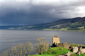
A romantic ruined castle on the shore of Loch Ness
Sprawling along a headland on the western shore of Loch Ness, Urquhart Castle is one of Scotland's largest medieval fortresses and among its most scenically sited. Once a stronghold fought over in the wars of independence, it was partly blown up in 1692 to keep it from Jacobite hands, leaving the atmospheric ruins you see today. Climb the Grant Tower for the classic view down the loch, where generations of visitors have scanned the water for Nessie. The visitor centre screens a short film and displays medieval finds. It is understandably popular, so arrive early or late in the day. Boat trips on the loch depart from nearby Drumnadrochit and Inverness.
Our tip Book a timed ticket online in peak season; the car park and site both reach capacity by midday.
Memberships and passes
- Historic Environment Scotland — entry included: Historic Scotland membership includes standard timed admission to Urquhart Castle and Historic Scotland daytime events. Advance member-ticket booking is recommended to guarantee entry; once online tickets sell out there is no walk-up availability. Car parking is free but limited and must be booked online in advance as part of the ticket booking. Third-party events and separately ticketed products require individual confirmation. Bring the member ticket plus a valid physical or digital membership card, temporary certificate or membership confirmation email. Official terms (checked 11 Jul 2026)
Access not yet checked — please confirm with the venue before you travel.
Worth watching
Also featured in The North Coast 500
Culloden Battlefield

The moor where the last Jacobite rising ended in 1746
Just east of Inverness, Culloden Moor is where the Jacobite cause was finally crushed on 16 April 1746, in the last pitched battle fought on British soil. The National Trust for Scotland's visitor centre is one of the best interpretive experiences in the country, using an immersive 360-degree battle theatre, first-hand accounts and artefacts to tell the story without glorifying it. Outside, the battlefield itself has been carefully restored, with flags marking the front lines and clan memorial stones dotted across the moor. It is a sombre, moving place, and walking the ground brings home the human cost far more than any film. Allow a good couple of hours.
Official information: Official website not yet identified.
Our tip Walk the battlefield trail after the exhibition; the clan graves and memorial cairn are deeply affecting.
Visiting — good to know
Step-free / wheelchair access Accessible parking Accessible toilets
For blind & low-vision visitors The 1746 battlefield with a fully accessible modern visitor centre and firm, largely level, audio-guided trails across the moor; open, exposed, poignant ground.
Sensory A calm, sombre, deeply moving open moor of wind and wide silence - reflective and quiet, busier at the centre.
Access last checked 5 Jul 2026 — always confirm with the venue.
Worth watching
More Wikipedia
Also featured in The North Coast 500
Cairngorm Mountain & Funicular

Scotland's only mountain railway into the high Cairngorms
Above Aviemore, the Cairngorm Mountain funicular railway carries visitors up the slopes to the Ptarmigan station near the summit plateau, home to the highest restaurant in the UK, in under ten minutes. It is the easiest way to experience the scale of Britain's largest mountain range, with vast views across Strathspey when the cloud lifts. This is a genuine Arctic-alpine environment, so it can be cold and blustery at the top even in summer. In winter it becomes one of Scotland's main ski centres. The wider area offers everything from gentle forest trails to serious Munro-bagging, plus a reindeer herd you can visit nearby.
Our tip Weather at the top is very different from the glen; take warm layers even on a bright day.
Plan your visit
- Opening
- The attraction is open year-round, currently 7 days a week except Christmas Day. In July and August, the official opening-times page lists the first train up at 10:00.
- Admission
- Mountain Railway day pass: adult £17.95 in advance or £19.95 on the day; junior £9.95 in advance or £11.95 on the day; student or senior £14.50 in advance or £16.50 on the day. A carer supporting a disabled passenger travels free but still requires a ticket.
- Booking
- Advance booking is not essential but is recommended, and booking online by the day before the visit saves money. Visitors with online QR-code tickets can go directly to the railway queue.
- Allow
- The railway journey takes approximately 5 minutes each way during the snowsports season and approximately 8 minutes each way outside it; total visit duration is not stated.
Visitor information checked 21 Aug 2026. Opening and prices can change.
Visiting — good to know
Partial wheelchair access Accessible parking Accessible toilets Assistance dogs welcome Companion goes free — all visitors
The funicular is fully wheelchair accessible, with lift access at the Base Station and Top Station. The resort says almost all facilities are accessible, but only levels 1 and 2 of the four-storey Day Lodge are accessible; accessible toilets are available at the Base Station. Outside the snowsports season, funicular passengers cannot leave the Ptarmigan building to access the mountain.
For blind & low-vision visitors High, arctic-like plateau walking above the treeline with exposure; a funicular runs up the mountainside (summit access may be restricted - check), giving an easier high viewpoint.
Sensory High, exposed and elemental above the treeline - wind the main sound; the funicular base can be busy, the plateau remote.
Companion concession Carers supporting a disabled passenger travel free, but a ticket is still required.
Access last checked 11 Jul 2026 — always confirm with the venue.
Worth watching
- CairnGorm Mountain - Funicular Railway CairnGorm Mountain Ltd
- I'VE WAITED 7 YEARS !! Finally the Cairngorm Mountain Railway, near Aviemore, is running again. Planes, Trains, Everything.
- Is the UK's Highest Train Worth It? 🏴 Cairngorm Mountain Railway Guide 2026| Aviemore Scotland The Non-Scottish Explorer
More Tickets · Venue access information · Wikipedia
Before you set off
The Highlands reward the well-prepared: download your maps, as mobile signal vanishes for long stretches; carry midge repellent from June to September; and book Skye accommodation well ahead in summer, when it fills months out. The weather writes its own itinerary, so keep a wet-day plan. And if you'd rather slow it right down — add the NC500 north coast, or the islands — open the trip in the planner and shape it around yourselves.