The North Coast 500 is Scotland's most celebrated road journey, looping roughly 516 miles around the elemental northern rim of the Highlands. Starting and finishing in the Highland capital of Inverness, it leads past ancient glacial glens, winds up Britain's steepest road pass, threads single-track shelves above turquoise Atlantic beaches, and reaches the wind-scoured clifftops at the very top of Britain.
This is big, remote driving country where preparation is paramount: single-track roads with passing places dominate, petrol stations can be 50 miles apart, and mobile signal vanishes for hours at a time. The terrain is often rugged, rocky and exposed to unpredictable Atlantic weather — we report verified accessibility where confirmed and say "not yet checked" honestly rather than pretend.
Fuel up whenever your tank dips below half, practice passing-place etiquette (always pull in to your left, never cross to the right), and give yourself four to five days minimum to avoid rushing through one of Europe's last great wildernesses.
Day one — Wester Ross and the Bealach na Bà
West from Inverness toward the Atlantic. The drive crosses the Black Isle and skirts Loch Carron before rising into the extraordinary hairpins of the Bealach na Bà — the Pass of the Cattle — climbing to over 2,000 feet with panoramas of Skye and the Outer Isles, before dropping to the tranquil shoreline of Applecross.
Applecross & Bealach na Bà

Britain's most spectacular hairpin pass to a remote coast
The Bealach na Bà, or Pass of the Cattle, is the most dramatic road on the North Coast 500 and one of the great drives in Britain. This old drovers' route climbs to 626 metres in a series of tight hairpin bends, the steepest ascent of any road in the UK, before dropping to the scattered crofting community of Applecross on its remote peninsula. The views from the top across to Skye and the Cuillin are extraordinary on a clear day. At the bottom, the Applecross Inn is a much-loved stop for local seafood. The pass is single-track, exposed and unsuitable for large vehicles or nervous drivers; the coast road round is the safer alternative.
Official information: Official website not yet identified.
Our tip Do not attempt the pass in a large motorhome or in poor visibility; take the low coast road instead.
Visiting — good to know
Partial wheelchair access
Chiefly experienced from a vehicle on the single-track hairpin road over the pass. The summit car park and Applecross village offer firm ground close to parking, but the ground beyond is rough, stony and exposed.
For blind & low-vision visitors A dramatic mountain pass (Britain's highest road climb) with hairpin bends and sheer drops - experienced from a vehicle; the summit and Applecross village have firm areas.
Sensory A wild, remote, elemental Highland pass and coast of wind and huge views - profoundly calm, busy only at the famous viewpoints.
Access last checked 6 Jul 2026 — always confirm with the venue.
Worth watching
More Wikipedia
Day two — Assynt and the dramatic northwest
North into the ancient Torridonian sandstone landscapes of Assynt. Pristine white-shell sand and vivid turquoise water at Achmelvich Beach, followed by the towering limestone sea cave and subterranean waterfall at Smoo Cave in Durness.
Achmelvich Beach
A dazzling white-sand bay in the wilds of Assynt
Tucked away on the coast near Lochinver in the far northwest, Achmelvich is one of those Highland beaches that stops you in your tracks: a small crescent of brilliant white shell-sand and clear turquoise water, framed by low rocky headlands and machair. It sits in the wild, ancient landscape of Assynt, beneath distinctive peaks like Suilven and Quinag. The single-track road in is narrow and twisting, which keeps numbers down, and the water, though cold, is irresistible on a sunny day. There is a small campsite and youth hostel behind the dunes. Bring everything you need, as facilities are minimal and the nearest shops are back in Lochinver.
Official information: Official website not yet identified.
Our tip Follow the coastal path north from the beach to find even quieter coves and the tiny "Hermit's Castle".
Visiting — good to know
Not step-free
Reached by a short, uneven sandy path from the small car park; the beach itself is soft shell-sand backed by uneven machair, with no firm, step-free route onto the sand.
For blind & low-vision visitors A white-sand cove reached by a short, uneven, sandy path with open sea; the sand is soft and the machair uneven - a guide helps.
Sensory A wild, remote, turquoise-water beach of surf and wind - profoundly calm and rarely crowded.
Access last checked 6 Jul 2026 — always confirm with the venue.
Worth watching
- Achmelvich beach Scotland, swim time The Travelling Yorkshireman vanlife UK
- Achmelvich Beach - Assynt - Scotland | 4K | DJI Mini 3 Pro and GoPro12 Scotland Far and Near
More Wikipedia
Smoo Cave, Durness
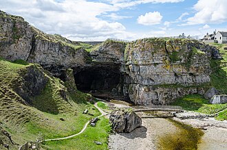
A vast combined sea and freshwater cave on the north coast
On the north coast near Durness, Smoo Cave is one of the most impressive and unusual natural features on the North Coast 500, and it is free to visit. Its main chamber has one of the largest cave entrances in Britain, formed by the sea, while an inner chamber holds a waterfall fed by a burn plunging through a hole in the roof above. A stepped path and walkways lead down into the entrance chamber, and in summer short boat trips take visitors deeper inside to see the waterfall up close. The surrounding coastline around Durness is spectacular, with beaches like Sango Sands and Balnakeil close by. Sturdy footwear helps on the damp steps.
Our tip Combine with nearby Balnakeil Bay and Cocoa Mountain chocolate shop at the craft village.
Visiting — good to know
Not step-free
A steep flight of steps leads down from the clifftop car park to the cave entrance, with wet, uneven rock and walkways inside - there is no step-free route into the cave. The clifftop viewpoint is beside the car park.
For blind & low-vision visitors A vast sea cave reached by a steep flight of steps down to the entrance, with uneven, wet rock and open water inside; not accessible below the clifftop.
Sensory A dramatic, echoing coastal cave of rushing water and sea - atmospheric and elemental, calmer than it is busy.
Access last checked 6 Jul 2026 — always confirm with the venue.
Worth watching
More Wikipedia
Day three — The northern edge and Caithness
Rounding the top of Britain. From Durness the road traces the peat bogs and sea cliffs of Sutherland into Caithness, reaching the famous northern milestone of John o' Groats and the dramatic offshore sea stacks of Duncansby Head.
John o' Groats

The famous northeastern tip and end-to-enders' finish line
John o' Groats is one of Britain's most famous signposts, marking the traditional finish of the Land's End to John o' Groats journey, even though the true northernmost point of the mainland is Dunnet Head, some miles to the west. The rebuilt harbour hamlet has a cluster of craft shops, cafes and the well-known signpost where everyone stops for a photo. From here you look out across the Pentland Firth to Orkney, and a passenger ferry runs across in summer. Nearby Duncansby Head, with its lighthouse and towering sea stacks, is arguably the more spectacular spot and well worth the short detour. It is exposed and often windy, so wrap up.
Our tip Drive on to Duncansby Head for the dramatic sea stacks; it beats the signpost for scenery.
Visiting — good to know
Partial wheelchair access
The signpost, harbour and visitor area are largely level and surfaced, with parking close by. The coastal paths beyond, towards Duncansby Head, are uneven, grassy and exposed.
For blind & low-vision visitors The far north-east tip with a largely level, defined signpost-and-visitor area and harbour; the cliff paths beyond are uneven and exposed.
Sensory A breezy, open, end-of-the-land spot of gulls and sea - calm and airy, gently busy at the signpost in season.
Access last checked 6 Jul 2026 — always confirm with the venue.
Worth watching
More Wikipedia
Day four — Loch Ness and the Great Glen return
South through the historic Highland corridor. The dramatic battlements of Urquhart Castle perched on the dark waters of Loch Ness, and the sombre, moving moorland of Culloden Battlefield where the 1745 Jacobite Rising met its tragic end.
Urquhart Castle & Loch Ness
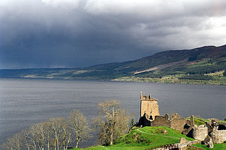
A romantic ruined castle on the shore of Loch Ness
Sprawling along a headland on the western shore of Loch Ness, Urquhart Castle is one of Scotland's largest medieval fortresses and among its most scenically sited. Once a stronghold fought over in the wars of independence, it was partly blown up in 1692 to keep it from Jacobite hands, leaving the atmospheric ruins you see today. Climb the Grant Tower for the classic view down the loch, where generations of visitors have scanned the water for Nessie. The visitor centre screens a short film and displays medieval finds. It is understandably popular, so arrive early or late in the day. Boat trips on the loch depart from nearby Drumnadrochit and Inverness.
Our tip Book a timed ticket online in peak season; the car park and site both reach capacity by midday.
Memberships and passes
- Historic Environment Scotland — entry included: Historic Scotland membership includes standard timed admission to Urquhart Castle and Historic Scotland daytime events. Advance member-ticket booking is recommended to guarantee entry; once online tickets sell out there is no walk-up availability. Car parking is free but limited and must be booked online in advance as part of the ticket booking. Third-party events and separately ticketed products require individual confirmation. Bring the member ticket plus a valid physical or digital membership card, temporary certificate or membership confirmation email. Official terms (checked 11 Jul 2026)
Access not yet checked — please confirm with the venue before you travel.
Worth watching
Also featured in Three days in the Scottish Highlands
Culloden Battlefield

The moor where the last Jacobite rising ended in 1746
Just east of Inverness, Culloden Moor is where the Jacobite cause was finally crushed on 16 April 1746, in the last pitched battle fought on British soil. The National Trust for Scotland's visitor centre is one of the best interpretive experiences in the country, using an immersive 360-degree battle theatre, first-hand accounts and artefacts to tell the story without glorifying it. Outside, the battlefield itself has been carefully restored, with flags marking the front lines and clan memorial stones dotted across the moor. It is a sombre, moving place, and walking the ground brings home the human cost far more than any film. Allow a good couple of hours.
Official information: Official website not yet identified.
Our tip Walk the battlefield trail after the exhibition; the clan graves and memorial cairn are deeply affecting.
Visiting — good to know
Step-free / wheelchair access Accessible parking Accessible toilets
For blind & low-vision visitors The 1746 battlefield with a fully accessible modern visitor centre and firm, largely level, audio-guided trails across the moor; open, exposed, poignant ground.
Sensory A calm, sombre, deeply moving open moor of wind and wide silence - reflective and quiet, busier at the centre.
Access last checked 5 Jul 2026 — always confirm with the venue.
Worth watching
More Wikipedia
Also featured in Three days in the Scottish Highlands
Before you set off
Book your accommodation well in advance for travel between May and September. Single-track etiquette is essential: let faster vehicles behind overtake by pulling into the next left-hand passing place, and never park inside passing places. Midges can be fierce in sheltered glens on calm summer evenings, so pack reliable repellent. If you want to customize your route or adjust stop durations to your own pace, open any day or the complete itinerary in the Roam Pal planner.\n