Britain's mountains are small by world standards and mighty in character: the crowded fells of the Lake District, the rock peaks of Snowdonia, and the vast, serious Highlands, where Ben Nevis tops them all and the Cuillin of Skye offer the hardest scrambling in the country. They are the making of the best British walking — and they demand respect, because weather and terrain turn them dangerous fast. This is a guide to the great peaks, with an honest note on what each really asks, and where a mountain railway or a gentler path opens the heights to more people.
Every peak here carries an access note, and honesty matters more here than anywhere: most true summits are hard, unforgiving ground for experienced, well-equipped walkers only, and we say so plainly. But we also flag the exceptions — Snowdon's rack railway, Cairn Gorm's funicular (when running), and the viewpoints and lower trails that share the grandeur without the summit. Mountain weather is lethal to the unprepared; check the forecast and go equipped. This guide grows as we add peaks.
England
The high fells of the Lake District, the Pennines and the Cheviots.
Scafell Pike

The 978m roof of England, deep in the western Lake District.
The highest point in England, a rugged dome of rock reached through the wild grandeur of Wasdale or Borrowdale — a classic of the Three Peaks Challenge.
Our tip Wasdale Head is the shortest (but still tough) route to the top.
Visiting — good to know
The summit is a demanding, rocky mountain walk — not accessible; the valley views from Wasdale are superb on the level.
For blind & low-vision visitors A demanding, pathless, rocky climb with exposure and drops — not accessible or safe for VI visitors; the valley of Wasdale below gives level, open views.
Sensory High, wild and exposed with wind the main sound; the valley base at Wasdale is calm, the summit remote — busy only on challenge days.
Access last checked 5 Jul 2026 — always confirm with the venue.
Worth watching
- Julia Bradbury and the Wainwright Walks Scafell Pike The Outdoor Guide with Julia Bradbury
- How to hike SCAFELL PIKE for beginners from Wasdale Head (the quickest route) George Soan
More Wikipedia
Helvellyn

A 950m fell famed for the knife-edge of Striding Edge.
Perhaps the most loved of the Lakeland fells, Helvellyn is approached by the exhilarating (and airy) Striding Edge, with a summit view over Ullswater and half of Lakeland.
Official information: Official website not yet identified.
Our tip Striding Edge is a scramble — the Thirlmere side is the easier ascent.
Visiting — good to know
Reached only by strenuous mountain walks, including the exposed Striding Edge scramble — not accessible.
For blind & low-vision visitors Reached by strenuous walks including the exposed Striding Edge scramble with sheer drops — hazardous, not for VI visitors; the Ullswater shore below is gentler.
Sensory Exposed and windswept with wide silence broken by wind; popular, so ridges can be busy on fine days, calmer midweek.
Access last checked 5 Jul 2026 — always confirm with the venue.
Worth watching
- How to Hike Helvellyn (Beginner's Guide) Stevie Tours
More Wikipedia
Skiddaw
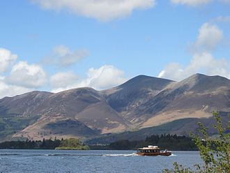
One of England's highest fells (931m), a broad whaleback over Derwentwater.
The great bulk of Skiddaw rises straight from Keswick — a long but non-technical hill walk to a summit with views over the northern Lakes and, on a clear day, Scotland.
Official information: Official website not yet identified.
Our tip It's a straightforward but relentless climb — pick a clear day for the view.
Visiting — good to know
A long, steep but non-technical hill walk to the top — strenuous, not accessible.
For blind & low-vision visitors A long, steep, relentless hill walk on open, exposed ground — strenuous and not accessible; Keswick and the Derwentwater shore below are far easier to orient by.
Sensory Open, exposed and windswept with little but the wind — a steady, quiet climb away from Keswick's bustle.
Access last checked 5 Jul 2026 — always confirm with the venue.
Worth watching
- Summiting Skiddaw and Wainwright Bagging! Backpacking UK
- SKIDDAW - England's 4th Highest Mountain Alan METALMAN – Outdoors
More Wikipedia
Great Gable

The iconic pyramid peak (899m) at the head of Wasdale.
The mountain whose profile forms the Lake District National Park's own emblem, Great Gable stands at the wild heart of the fells above England's deepest lake.
Official information: Official website not yet identified.
Our tip The summit war memorial is a moving spot on Remembrance Sunday.
Visiting — good to know
A steep, rough mountain walk to the summit — not accessible; magnificent seen from the valley.
For blind & low-vision visitors A steep, rough mountain climb with exposure — not accessible; magnificent from the level valley floor at Wasdale, where the views are open and safe.
Sensory Remote, rocky and exposed with wind and silence — calm and elemental, rarely crowded away from the popular cols.
Access last checked 5 Jul 2026 — always confirm with the venue.
Worth watching
- LAKELAND WALK - Great Gable via Little Hell Gate Terry Abraham - Lake District Filmmaker
- Great Gable // The Lake District Black Crag
More Wikipedia
Kinder Scout

The highest point in the Peak (636m), a vast peat moorland.
A brooding plateau of peat groughs and gritstone, Kinder Scout is the Peak District's summit and the site of the 1932 Mass Trespass that won the right to roam.
Official information: Official website not yet identified.
Our tip The Mass Trespass history makes this hallowed ground for walkers.
Visiting — good to know
A steep climb onto a wild, exposed peat plateau — for hillwalkers only.
For blind & low-vision visitors A steep climb onto a wild, exposed peat plateau with hidden groughs and drops — pathless and hazardous, for hillwalkers only, not VI visitors alone.
Sensory A vast, wild, silent plateau of wind and open sky — profoundly calm and remote, rarely anyone about.
Access last checked 5 Jul 2026 — always confirm with the venue.
Worth watching
- Kinder Scout Circular Walk from Hayfield! | Peak District, UK Kitti and Jon
- Best Walks With A View - Edale Route Overview The Outdoor Guide with Julia Bradbury
More Wikipedia
The Cheviot

The highest of the remote Cheviot Hills (815m).
A great whaleback of a hill on the Scottish border, the Cheviot crowns its own wild, empty range of rolling grass and peat — some of England's loneliest walking.
Official information: Official website not yet identified.
Our tip The going is famously boggy — the summit paving helps near the top.
Visiting — good to know
A long, boggy moorland walk to a remote summit — not accessible.
For blind & low-vision visitors A long, boggy, featureless moorland walk to a remote summit — disorienting and not accessible; the paved path helps only near the top.
Sensory Empty, boggy and silent but for wind and curlew — one of England's loneliest, calmest hills.
Access last checked 5 Jul 2026 — always confirm with the venue.
Worth watching
- The CHEVIOT!! Northumberland's highest summit! Sherlock's Grumpy Wanders
- FIRST TIME WALKING IN THE CHEVIOT HILLS - THE CHEVIOT via the spectacular gorge - HEN HOLE Small Feet Pete
More Wikipedia
Ingleborough

One of the Yorkshire Three Peaks (723m), above cave country.
The distinctive flat-topped Ingleborough rises over the limestone of the Dales, riddled with caves and pot-holes, one of the celebrated Yorkshire Three Peaks.
Official information: Official website not yet identified.
Our tip Combine it with the Ingleton Waterfalls Trail for a full Dales day.
Visiting — good to know
A strenuous walk over limestone and moor to a flat summit — not accessible.
For blind & low-vision visitors A strenuous walk over limestone and moor with pot-holes, uneven ground and a steep final climb — hazardous and not accessible for VI visitors alone.
Sensory Open moorland with wind and wide views; busy on Three Peaks days, otherwise a quiet, exposed climb.
Access last checked 5 Jul 2026 — always confirm with the venue.
Worth watching
More Wikipedia
Wales
Snowdonia's peaks — Yr Wyddfa, Cadair Idris and the rock spire of Tryfan.
Snowdon (Yr Wyddfa)

Yr Wyddfa (1,085m) — and the only British summit with a railway.
The highest mountain in Wales and England, Yr Wyddfa is climbed by six walking paths — but also, uniquely, by the Snowdon Mountain Railway, which carries visitors to a summit visitor centre.
Our tip The rack railway from Llanberis gives a rare step-free route to a mountaintop.
Visiting — good to know
Walking routes are strenuous, BUT the Snowdon Mountain Railway carries visitors to the summit — a rare accessible mountaintop (railway operating/weather permitting).
For blind & low-vision visitors Walking routes are strenuous and exposed, BUT the Snowdon Mountain Railway carries visitors to the summit — a rare step-assisted mountaintop; the summit itself is exposed with open drops (railway/weather permitting).
Sensory The summit is busy and can feel crowded (railway and walkers together), with wind and chatter; the quieter paths and early trains are calmer.
Access last checked 5 Jul 2026 — always confirm with the venue.
Worth watching
More Wikipedia
Cadair Idris

A brooding 893m mountain of legend in southern Snowdonia.
Legend says a night on Cadair Idris leaves you a poet or a madman; its glacial cwm and dark lake make it one of Wales' most atmospheric mountains.
Official information: Official website not yet identified.
Our tip The Minffordd Path past the lake is the finest (and steepest) route.
Visiting — good to know
Steep, rocky mountain paths to the summit — not accessible.
For blind & low-vision visitors Steep, rocky mountain paths with exposure and drops to a dark lake and summit — not accessible; the lower Minffordd approach is gentler but still uneven.
Sensory Wild, rocky and atmospheric with wind and silence; the Minffordd start can be busy on fine days, the mountain otherwise remote.
Access last checked 5 Jul 2026 — always confirm with the venue.
Worth watching
- The Best Hiking Route up Cadair Idris: The Minffordd Path The Bald Scrambler
- Cadair Idris: The Easiest Route to the Summit The Bald Scrambler
More Wikipedia
Tryfan

A dramatic 918m rock peak crowned by the Adam & Eve stones.
One of the few British mountains that cannot be climbed without using your hands, Tryfan's jagged rock rises above the Ogwen valley, topped by two monoliths brave walkers leap between.
Official information: Official website not yet identified.
Our tip This is a scramble, not a walk — for the experienced and sure-footed.
Visiting — good to know
A hands-on scramble to the top — for experienced scramblers only, not a walk.
For blind & low-vision visitors A hands-on rock scramble with exposure and big drops — for experienced scramblers only, not safe for VI visitors; best appreciated from the Ogwen valley road below.
Sensory Steep, rocky and exposed with wind and the sounds of scramblers — a focused, intense environment rather than a crowded one.
Access last checked 5 Jul 2026 — always confirm with the venue.
Worth watching
- Tryfan - Alex Rambles Alex Foxfield
More Wikipedia
Pen y Fan

The 886m summit crowning the Brecon Beacons.
The highest point in southern Britain, Pen y Fan's flat-topped sandstone summit is a popular but rewarding climb with vast views over the Brecon Beacons.
Official information: Official website not yet identified.
Our tip The 'motorway' path from the Storey Arms is the busiest but easiest route.
Visiting — good to know
A popular but steep walk to the summit — strenuous, not accessible.
For blind & low-vision visitors A popular but steep, exposed walk on open ground to a high summit — strenuous and not accessible, with drops from the summit ridge.
Sensory The most-climbed peak in South Wales — busy on fine days on the main path, with wind and chatter; quieter routes are calmer.
Access last checked 5 Jul 2026 — always confirm with the venue.
Worth watching
More Wikipedia
Scotland
The Highlands and islands — Ben Nevis, the Cairngorms and the Cuillin.
Ben Nevis

The 1,345m giant above Fort William.
The roof of Britain, Ben Nevis hides a mile-wide cliff on its north face; most climb the long 'Mountain Track', though the summit is often in cloud.
Our tip The Nevis Range gondola nearby gives an easier high viewpoint.
Visiting — good to know
The summit is a long, serious mountain walk — not accessible; the nearby Nevis Range gondola offers an accessible high viewpoint.
For blind & low-vision visitors The summit is a long, serious mountain walk with cliffs and frequent cloud — not accessible; the nearby Nevis Range gondola offers a step-assisted high viewpoint instead.
Sensory Busy on the Mountain Track on fine days, but high, exposed and often cloud-wrapped with wind the main sound.
Access last checked 5 Jul 2026 — always confirm with the venue.
Worth watching
- Ben Nevis: The Tourist Path Linda Outdoors
More Wikipedia
Cairn Gorm

A 1,245m mountain above Aviemore, with a funicular railway.
In the heart of the Cairngorms, this high, arctic-like plateau peak rises above Aviemore and the Rothiemurchus forest, served by a mountain funicular railway.
Official information: Official website not yet identified.
Our tip Check the funicular's current operation and summit-access rules before visiting.
Visiting — good to know
High mountain walking above the treeline; a funicular runs up the mountainside (summit access may be restricted) — check current operation.
For blind & low-vision visitors High, arctic-like plateau walking above the treeline with exposure; a funicular runs up the mountainside (summit access may be restricted — check), giving an easier high viewpoint.
Sensory High, arctic and windswept above the treeline — exposed and elemental; the funicular base can be busy, the plateau remote.
Access last checked 5 Jul 2026 — always confirm with the venue.
Worth watching
- Walking up Cairngorm Glynn Henderson
More Wikipedia
Ben Lomond

A 974m peak rising straight from the shores of Loch Lomond.
The most southerly of Scotland's Munros and one of the most climbed, Ben Lomond soars above the bonnie banks with a grandstand view down the loch.
Our tip The Ptarmigan route makes a fine circuit with the tourist path.
Visiting — good to know
A popular but strenuous mountain walk from Rowardennan — not accessible; grand loch views from the shore.
For blind & low-vision visitors A popular but strenuous, exposed mountain walk with drops — not accessible; the level shore of Loch Lomond below gives grand, safe views.
Sensory A popular Munro that can be busy on the path on fine days, with wind and wide silence; the loch shore below is livelier.
Access last checked 5 Jul 2026 — always confirm with the venue.
Worth watching
More Wikipedia
Buachaille Etive Mòr

The iconic pyramid peak at the entrance to Glen Coe.
Perhaps Scotland's most photographed mountain, the 'Great Herdsman of Etive' rises as a near-perfect pyramid where Rannoch Moor meets Glen Coe.
Official information: Official website not yet identified.
Our tip The classic view is from the roadside at Glen Etive — no climb needed.
Visiting — good to know
A striking mountain best seen from the road at Glencoe; the climb itself is for experienced hillwalkers.
For blind & low-vision visitors A striking pyramid best experienced safely from the roadside at Glen Etive/Glencoe — level, open views; the climb itself is for experienced hillwalkers only.
Sensory Dramatic and much-photographed from the road (busy layby), but the mountain itself is wild, silent and exposed with wind.
Access last checked 5 Jul 2026 — always confirm with the venue.
Worth watching
- Hiking up Scotland's Most Photographed Mountain.. The Buachaille Scottish Munro Journey
More Wikipedia
Schiehallion

A shapely 1,083m Perthshire Munro used to 'weigh the world'.
This elegant cone was used in 1774 to estimate the mass of the Earth — the experiment that led to contour lines; today it's a popular, well-pathed Munro.
Official information: Official website not yet identified.
Our tip The John Muir Trust path makes this one of the more approachable Munros.
Visiting — good to know
A steep hill walk to the summit — not accessible, though the path is good.
For blind & low-vision visitors A steep, well-pathed but exposed hill walk with uneven, rocky ground to the summit — strenuous and not accessible, though the path is good lower down.
Sensory An open, conical hill with wind and wide silence; popular but spread out — calm and exposed rather than crowded.
Access last checked 5 Jul 2026 — always confirm with the venue.
Worth watching
- Schiehallion Munro - A Munro Milestone Scottish Munro Journey
More Wikipedia
Suilven

A spectacular 731m sugarloaf rising alone from the Assynt wilderness.
Though not high, Suilven is unforgettable — a great isolated dome of ancient rock rising sheer from the lochan-strewn moors of Assynt in the far north-west.
Official information: Official website not yet identified.
Our tip The long walk in is part of the adventure — a full day's expedition.
Visiting — good to know
A very long, remote approach and steep climb — a serious mountain expedition.
For blind & low-vision visitors A very long, remote approach and steep climb — a serious mountain expedition, not accessible; its dramatic dome is best seen across the Assynt moors.
Sensory Utterly remote and silent — a wild, solitary Assynt setting of wind, bog and birds, rarely another walker.
Access last checked 5 Jul 2026 — always confirm with the venue.
Worth watching
- Suilven – Alex Rambles Alex Foxfield
More Wikipedia
The Cuillin, Skye

The jagged Black Cuillin ridge, a mountaineer's dream on Skye.
The serrated Black Cuillin is the most demanding mountain range in Britain, its gabbro peaks a mecca for climbers; the Red Cuillin and the views around it are gentler.
Official information: Official website not yet identified.
Our tip You don't have to climb — the views from Sligachan and Elgol are sublime.
Visiting — good to know
The Black Cuillin ridge is for mountaineers only; the roadside views from Sligachan and Elgol are accessible.
For blind & low-vision visitors The Black Cuillin ridge is a mountaineers' domain of exposure and sheer rock — not for walkers; the accessible experience is the level roadside views from Sligachan and Elgol.
Sensory Wild, sheer and elemental with wind and rock; the roadside viewpoints are calm and open, the ridge intense and remote.
Access last checked 5 Jul 2026 — always confirm with the venue.
Worth watching
- The Narrowest Ridge in Britain? The Central Cuillin Munros Scottish Munro Journey
- HIKING THE THINNEST ARETE IN THE UK ON THE CUILLIN RIDGE - ISLE OF SKYE The Scottishmaninavan
More Wikipedia
Goat Fell, Arran

The 874m high point of the Isle of Arran, above Brodick.
The highest point on Arran — the island often called 'Scotland in miniature' — Goat Fell rises above Brodick Castle with views across the Firth of Clyde to the mainland.
Our tip The path starts from Brodick Castle's grounds, a lovely accessible base.
Visiting — good to know
A strenuous walk from Brodick to the summit — not accessible; fine views from the castle grounds below.
For blind & low-vision visitors A strenuous, exposed walk from Brodick to the summit with drops — not accessible; the level grounds of Brodick Castle below give fine, safe views.
Sensory An exposed island summit with wind and sea views; busy on fine ferry days on the path, calm and airy at the top.
Access last checked 5 Jul 2026 — always confirm with the venue.
Worth watching
- Isle of Arran | Part - 1 | Travel Scotland | Goat Fell | Indie Traveller | UK Vlogs Indie Traveller
- Climbing Goatfell – Epic Hike on Arran with a Well-Earned Pint! The Ayrshire Traveller
More Wikipedia
Before you go
Mountains are the one place where "not yet checked" often means "seriously hard", and we won't dress it up: read each peak's note, and treat the summits as expeditions needing proper kit, navigation and a weather eye. For the grandeur without the danger, look to the railways (Snowdon), the funiculars, and the lower viewpoints. And if you'd like to plan around a few, open the planner and shape it around how you travel — with your own access needs applied throughout.